Monday, February 28, 2011

Day Eight; the first of many in Louisiana

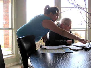
We decided to try a series of Texas Farm to Market roads to avoid freeways in the Dallas area. This might have worked better if William had gone over the route with me prior to departure. Here is William planning the route with Val in a picture shot by Ben.
Farm Roads can change direction abruptly and although you may be going in the most traveled direction your Farm Road may have cut off to the left or the right. William said why are there no big road signs and I said if people are driving here they already know where they are and the small signs telling you that you are in Wylie or Emory are sufficient.

We needed to freshen up our groceries a bit so we stopped in a Brookshire in Emory. We pulled out of the parking lot and went a bit before we realized that we were on the wrong road. We had entered the parking lot prior to an intersection and exited after the intersection and the road we wanted had taken a jog.

Farm Roads are also fun to drive with no shoulder, narrow lanes and 55MPH traffic that feels like you are flying along a tiny curvy track. We crossed Lake Lavon twice in different directions on different roads. Gray shallow water with skinny tree trunks sticking up like sparse dark hair and tiny white caps from the fierce wind on the narrow bridges. This is where Val's tap water comes from. Water is sucked up out of the reservoir into a tall water tower so the water can flow to the houses and come out of the taps smelling like a swamp.

Finally we found Route 69. We decided to just follow it to I20 and then I49 rather than do any more fooling with back roads. But you do miss a bit of the countryside. Once we were on the interstate with wide mowed meridians and verges bordered by skinny short needle pines and hardwoods, we might have been on an interstate south of Jacksonville FL except for no kudzu.

We pulled off at Ajax into the Country Living RV park. Quiet now that the small sawmill across the road has shut down for the day. William shot a few pictures and spent time looking for the resident alligator in the RV park pond. That alligator is sleeping on the job as he has missed a few little yipper dogs tied up outside RV's.


William found no sign of the alligator, though he was told it had been seen today.


Ajax, Louisiana sawmill

Sunday, February 27, 2011

Day Seven in Lucas

A long day at the laundermat because the dryer is not working right. Ben ate a huge lunch at Cici's and had fun taking pictures. We also went out to dinner at Mexigo.
Ben's cleaned dinner plate
Richard and Robert at dinner
Self portrait of the artist
More self portraits of the artist
The artist doing tricks
Grandma
Ben and the car
Ben at Lunch

Saturday, February 26, 2011

Day Six in Lucas

Ben's I Love You Bear hanging up.
Ben, Santa bear and I Love You bear.
Ben and Santa Bear
This is I Love You bear.
Just my Ben

We are here at Valerie's. I played with Ben so much this afternoon that he fell asleep in the middle of his bedtime story. We played in the RV with him wanting to know all about everything. Then we played upstairs with trains, cars, a Scooby puzzle and a ball. We talked and talked about how much we would play together when he moves and lives near me.

Friday, February 25, 2011

Day Five into Texas

Spending the night in Midessa Oil Patch RV Park and I have nothing I want to say about Texas.

Thursday, February 24, 2011

Day four of the journey

Scrubby desert landscape with red dry mountains at the edges of the flat. Luckily no dust storms again. We were going to stay at Rockhounds State Park outside of Deming, but it was full. It is a small park that caters to a certain interest group, those who like to pick up rocks, geodes, etc., since you are allowed to gather.
So we drove on to Los Cruces and just found an RV park. Very windy. Must be near Texas.

Nice big road runner very visible from the freeway as you enter Los Cruces.
Freezing in the wind with a blah sunset.

Day three on into Arizona Wednesday 2/23/2011

So we are looking for downtown Needles for a store and I see 8 foot clearance ahead and it all comes back. A few years ago we came through Needles and we were looking for a picnic spot near the river and came right up against this railroad underpass from the other direction. We came pretty close that time and had to turn around right in front of it. We are 9 ½ feet tall. This time we knew it was serious and we detoured at the next corner. Turned out there was no grocery store until you are out of downtown. We found the Bashas and I found my Bashas card. I'm pretty good with grocery cards for the Southwest. The Southeast will be something else. If we see a Piggly Wiggly, we'll have to stop and shop just so I can get a card as a souvenir.
Heading through beautiful downtown Phoenix, reminiscing about the horrible dust storm we encountered our last time through. That was bad. Now just a lot of traffic even though it is only around 2PM. Not as bad as the other side, they are totally stopped due to a crash.
Finally we are at Picacho Peak State Park. Pretty nice park and there was a historic civil war battle fought here. The South was trying to expand to have more slave owning territories and to keep the blockade that the North had imposed from being effective. Confederate troops came out from Texas and took control of the southern part of Arizona, which was still a territory. Union troops came from Yuma and the battle was fought at Picacho Pass. It was basically an ambush and the South won this battle. Thank you Google on the Droid for the information. The park gave us no information, although they do have a reenactment March 12-13. We are only staying here one night.

Out the front door, sunset light on the peak
Sunset at Picacho Peak

Tuesday, February 22, 2011

Day Two on to Needles


The sky was clear and crisp as we pulled out from Lone Pine. We soon came upon Owens Lake with water in it. There must have been quite a bit of rainfall. Los Angeles Water District has been under court order for years to work on getting enough water in the lake to prevent toxic salt from blowing around. Such a sad story. The Owens river valley used to be full of orchards and farms. Then through hook and crook LA gained the water rights and shipped all the water to LA until the lake dried up. You would never believe there had once been farms and orchards here.
This was a very large solar farm. Too bad there are not many more of these. One other thing that I noticed as we drove along was no independent trucks. Remember the truck doors decorated with the drivers name. I saw none. All company trucks. Have independent truckers gone away in the recession?Here we are in Needles next to the Colorado River. We got here early enough to sit out in the sun.

Monday, February 21, 2011

Day One the Flight From the Snow

We made the break after the storm and the road was dry over Donner. Highway 20 was wet, but it is shaded by all those trees. William is washing off the RV now as it got very dirty from road mist. We made it all the way to Boulder Creek RV Resort outside of Lone Pine. A good days travel for us. Highway 395 is our favorite way to drive South, because of the view of the back side of the Sierras. Millions of years ago a crack formed in Nevada and the California side rose up. Over the millennia it has eroded to sharp peaks on the Nevada side and softer slopes down on the California side. But everybody knows this. We saw a few fumerals, quite a few hot springs on the Nevada side. Approaching the Five Mile House.Driving past the five Mile House
More Snow Still Covers the Trees
If you look closely, you can see the ice dripping from the leaky flume.
Thinking of FrankWe rolled right past the Basque Restaurant in Gardnerville. If you eat lunch there, you'll get so sleepy you'll be lucky if you make it to Topaz Lake to camp. But the driver is blowing right past Topaz.Beautiful mountains near Mammoth.Finally near Bishop the snow is only on the mountains and not on the ground.

Sunday, February 20, 2011

Wolverine


In early August of 2008 we went camping at Gold Lake. As we were getting ready to leave I saw a mid sized chocolate furry animal run across the open area in front of me to the edge of the lake and then run back. At the time I thought it might have been a Pacific Fisher, but now I am sure I saw the male wolverine that has been tracked on the Tahoe National Forest since 2008. My sighting would have put the animal rather further north of the range noted in the Sac Bee article today. I am adding myself to the list of the few people who have seen Buddy.
At the time I contacted the local Forest Service and they convinced me that I must have seen a Pacific Fisher, although I had picked the wolverine out of images and thought the size of the animal I saw fit a wolverine better than a fisher. I think it was not widely known in August of 2008 that a lone male wolverine had been found on the forest.